The mathematical models that compose the forecasting system and their related results are:
- Meteorological model (Responsible partner LMC-AUTH):
- total precipitation,
- atmospheric pressure at sea level,
- air temperature (2m),
- relative and specific humidity,
- wind fields (10m) and
- heat and radiation fluxes
- Wave model (Responsible partner LMEMW-AUTH):
- wave height and direction
- Coastal circulation model (Responsible partner LMEMW-AUTH):
- meridional and zonal currents and
- thermohaline properties
- Storm surge model (Responsible partner LMEMW-AUTH):
- Mean Sea Level Heights (MSLH)
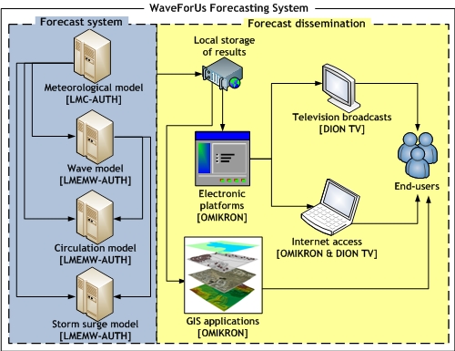
Schematic representation of the forecasting system
- Television broadcasts (Responsible partner DION TV):
- Two daily 5-minute wave and circulation forecast bulletins, where the scientific information is provided in a simplified manner, to be directly exploitable by the users. These broadcasts are also available through the webpage of DION TV, so as to continuously inform the public.
- Non-scheduled risk warning broadcasts of coastal flooding in the event of significant (> 30cm) elevation of the MSLH
- Geographic Information System (GIS) web applications (Responsible partner OMIKRON). The web-GIS platform consists of:
- A metadata compilation and data upload tool
- A central data repository
- A metadata search and download facility
- Documents and tools
- Internet accessibility of digital maps (Responsible partner LMEMW-AUTH):
- The forecasts are also available through this site (under the link 'forecasts') in the form of digital maps of the forecasting parameters (wave, current, thermohaline properties, MSLH) spatial distribution