The modelling platform used for the prognosis of wave climate, coastal circulation and sea level height consists of the following sequence of numerical models:
-
Meteorological model: Weather Research and Forecasting model with the Advanced Research dynamic solver (WRF-ARW, Version 3.2.0)
Responsible partner: LMC-AUTH - Wave model: WaveWatch-III (WW-III, version 3.14)
Responsible partner: LMEMW-AUTH - Coastal circulation model: Princeton Ocean Model (POM, Version 2008)
Responsible partner: LMEMW-AUTH - Storm surge model: High Resolution Storm Surge model (HRSS)
Responsible partner: LMEMW-AUTH
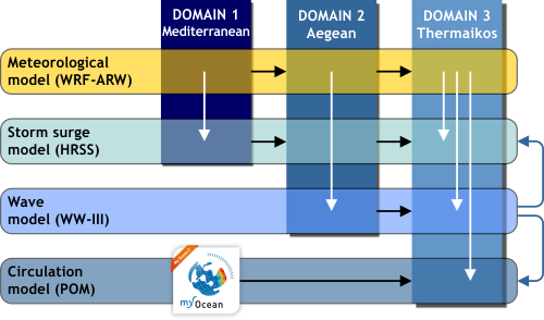
Fig.1: Representation of the forecast models and their application domains. Black arrows denote transfer of initial and boundary conditions, while white arrows show the introduction of input data and blue ones denote coupling between models.
- Mediterranean Sea (Domain 1) with spatial step of 0.15°x0.15°(~15km)
- Aegean Sea (Domain 2) with spatial step of 0.05°x0.05°(~5km) και
- Thermaikos Gulf (Domain 3) with spatial step of 0.016°x0.016°(~1.7km)
One-way coupling between sea-state models (blue arrows in Fig.1) is performed: (a) introducing the results of the wave model to the circulation model, in order to take into account the effects of radiation stresses and Stokes drift velocities in the circulation prognoses and (b) using the sea level heights simulated by the storm surge model to update the water depth in the domain for the wave model calculations.
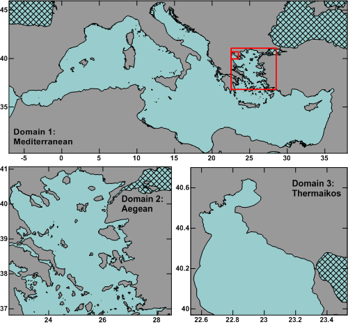
Fig.2: The 3 domains of application of the forecast models. The shaded areas are not included in the calculations.
The model will be modified so as to produce the required result fields at operational level. It will be activated daily with a prognosis horizon that covers 72 hours (3 days). The results that will be disseminated to the sea forecast models at an hourly step are: accumulated precipitation, mean pressure at sea level, temperature, specific and relative humidity at 2m, u and v wind components at 10m, short and long wave radiation fluxes at the surface and latent and sensible heat fluxes at the surface. The WaveWatch III (WW-III), version 3.14 (Tolman, 2009) numerical model is a third generation spectral model for the simulation and prognosis of wind-generated wave fields. It was developed at the Marine Modeling and Analysis Branch (MMAB) of the National Center for Environmental Prediction (NCEP). The governing equations of WW-III include refraction and straining of the wave field due to temporal and spatial variations of the mean water depth and of the mean current. Parameterizations of physical processes (source terms) include wave growth and decay due to the actions of wind, nonlinear resonant interactions, dissipation (`whitecapping'), bottom friction, surf-breaking (i.e., depth-induced breaking) and scattering due to wave-bottom interactions. Princeton Ocean Model (POM) is a widely applied and validated model for the simulation of various environments, including coastal circulation and mixing processes in rivers, estuaries, shelves and slopes, lakes, semi-enclosed seas, as well as the global ocean. It is an open-source, freely distributed model and it is continuously under improvements through feedback and applications provided by the users. POM (Blumberg and Mellor, 1987) is a three-dimensional, free surface, terrain following model that includes a higher order turbulence closure scheme (Mellor and Yamada, 1982). The model can simulate baroclinic and barotropic circulation and provide prognoses regarding current velocities and directions, Mean Sea Level Heights (MSLH) and thermohaline properties of seawater. High Resolution Storm Surge (HRSS) (Krestenitis et al., 2010) is a two-dimensional hydrodynamic model that can prognose the evolution of the MSLH, taking into account the effects of atmospheric parameters (wind fields and pressure gradients), astronomical tides and wave climate (wave radiation stresses), solving the Navier-Stokes equations in the two-dimensional domain. The calibration of the model parameters mainly involves the value of the surface shear stress coefficient and the inclusion of the effects of waves and was performed using in-situ sea level measurements and satellite altimetry data (Jason 2, NOAA) for the period of 2012-13.